Day 10: Zion National Park

This morning was a short drive over to Zion National Park – only about 90 miles.  I got on the road about 8:30 and after stopping to top off the tank just outside the park I hit the gate about 10:30.  Asked the ranger which campground was best.  His answer, “whichever one you can find a spot in.  They’ll likely be full in the next few minutes”.  That didn’t bode well.  Neither did all the traffic in front of me.

When planning this trip I had tried to reserve a campsite in Zion but there are only a limited number available for this.  Most are simply first come, first serve.  I was hoping that since I was arriving on a Monday, before noon, I would be OK.  There are two campgrounds in the park and as I approached the first, the sign at the entrance said “Full”.  Ditto for the second.  Uh-oh.

So I ended up at the visitor center and decided to hop the shuttle up the scenic route – no private cars allowed except during the off-season.  I got off at two stops, the first just snapped a few shots, the second took a 2 mile hike along the river to the “Narrows” where the canyon narrows to a slot.  From there it was back to the car and decision time.

DSC_0883

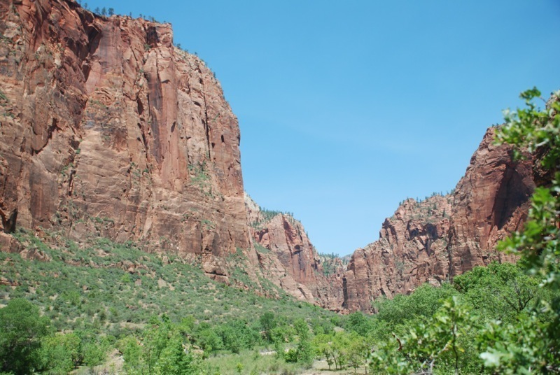
I have mixed feelings about Zion.  Without doubt it is one of the most beautiful parks, but it’s ridiculously crowded.  The campgrounds are in the bottom of the canyon near the visitor center and even today in late May it was very hot – hindsight I’m actually glad I couldn’t get a campsite.  The lodge rates were from $175-$200 a night – they had vacancies but I wasn’t going to pay that.  So I headed out of the park and of course all the hotels in the little town were filled.  I had decided by this time that I didn’t want to come back to Zion tomorrow as originally planned given all the crowds and the distance I’d likely have to drive.  So it was on to Cedar City which is near my next planned sight anyway – Cedar Breaks National Monument.  I put my Hilton Honors points to good use and am staying at a Hampton Inn tonight.  A nice break from the camping.  Besides it was awfully hot today…

I certainly want to come back to Zion as there are a lot of areas that I didn’t get to see and there are a number of hikes that I would like to do.  But given the crowds it seems like a visit here really needs to be in the off-season and more importantly needs to be a destination rather than a side trip as was the case this time.

Onwards!

Day 9: Eclipse Day at Bryce Canyon NP!

A beautiful day for an eclipse – clear blue sky and just a little wind!

I started the day at the park by just driving up the scenic drive again, this time capturing it in real time on my camera to compare with the time-lapse that I took yesterday.  After that I parked the car at Sunrise Point and headed off to hike the Navajo Loop Trail.

The Navajo loop is a 1.3 mile trail that goes down 0.6 miles and then back up 0.7 miles if you go in the clockwise direction.  Yesterday near the end of my 6 mile hike I took the 0.6 mile section up.  So today I went down that side and came back up the other way which I hadn’t seen yet.  On this leg which is called “Wall Street” the trail goes through a narrow slot canyon which makes for some spectacular views up the vertical walls to the open sky and also through the canyon looking at the switchbacks you have to climb to get out.  It took me about an hour to do this given all the photos I had to stop and take;-)

After that I headed to the Bryce Canyon Lodge and had a leisurely lunch.  From there I headed back to my car since I had seen enough of the canyon for awhile.  Just did a little reading and relaxing until about 3:30 when I headed down the road to grab a shuttle ride out to Bryce Point.  Turns out I should have taken that time to check my equipment – I had forgotten my tripod back at camp.  I was going to be forced to take pictures of the eclipse the hard way.

Made it out to Bryce Point about 4 pm and got myself situated right on the rim across from the Bryce Amphitheater.  There were hundreds of people at Bryce Point and I don’t know how many at the other sites.  Chatted with a nice couple from Eugene, OR while waiting for the show to start.  She’s French Canadian and he’s Czech and they had also lived in Owatonna, MN for awhile in the 80s.

DSC_0190

It took me a few tries to dial in the settings on my camera to get images of the sun (should have had a neutral density filter…) but I finally got as best as could be.  The sun was still too bright for about the first half – even though I could see through the eclipse glasses the transit, it still caused overexposure of the sun.  But as the moon got a bit more than halfway across the sun, I could start to see a crescent in my images.  Then at the maximum I got the image above.  I then continued snapping photos through the remainder of the eclipse – all the way to sunset.  I’m going to assemble a time lapse of this as well but unfortunately since I did this all handheld I’m going to have to crop a lot of images otherwise it’ll be jumping all over the place.

After that it was a bit of waiting for the shuttle ride back to my car (or close to my car anyway).  Not sure if it’s always so disorganized, they also had one bus break down, but I think I waited nearly an hour.  This was after also sitting through the entire eclipse – most people had headed to the busses just after the maximum.  Then it was back to camp and bed.  On to Zion tomorrow!

Day 8: Bryce Canyon National Park – Day 2

Last night was another very windy night and I didn’t get much sleep.  Fortunately the modifications that I made to the rain fly during the day yesterday did go a long way in keeping additional sand out of the tent – so at least I didn’t have that flying in my face all night.

Today I had planned to be just a hiking day, but I realized that I had missed two of the viewpoints during my visit yesterday – Yovimpa Point and Piracy Point.  So on returning to the park this morning I ran out to those two viewpoints and got some pictures.  Then headed down to Sunset Point to start my hike.

While yesterday was a more or less cloudy day with less than optimal lighting conditions, today was absolutely perfect.  The sky was clear with just an occasional lazy cloud and the most stunning shade of blue.

The hike I chose was actually a combination of three trails; Queen’s Garden, Peek-a-Boo Loop and Navajo loop.  These take you down into the Bryce Amphitheater so that you are down in and amongst the hoodoos.  The lower section takes you through a nice conifer forest.  The total length is somewhere around 6 miles.  The Navajo loop is the steepest section as far as I can tell and is completely uphill/downhill with no flat sections.  After making it up one side of the loop I had the option of going down the other side and back up again (1 mile total) – or just taking the remaining half mile back to the car – I chose the car.  I’m planning to do the rest of Navajo loop tomorrow morning as from the top it does look very interesting.

DSC_0305

The rest of tomorrow will be getting ready to view the eclipse which starts at about 6:20 MT and lasts about 2 hours.  I already have my snazzy eclipse viewing glasses!

Day 7: Bryce Canyon National Park – Day 1

After reviewing my options, I decided that today would be the day to simply take the drive up the length of the park and stop at all the scenic overlooks in the park.  In 18 miles there are 14 stops – I think I hit them all…

DSC_0259

They’re all very similar but I think my favorite was Inspiration Point which is where the above photo was taken.  The day started out very nice, despite the clouds that almost made me reconsider.  However as the day drew on it started to cool off and there was a brief shower of freezing rain that finally made me put the top up for good.  I made it back down to the visitors center and was able to catch a presentation of their 20 minute “intro to Bryce Canyon” movie.

After that it was raining and the wind was blowing quite a bit, so I hung out at the visitor center for about a half hour or so until it finally stopped.  I made it out to the last viewpoint and called it a day.

Got back to my campground about 5 o’clock and fortunately my tent was still standing.  One of the campground staff said they had a 51mph gust of wind blow through and for a time visibility was virtually 0 with all the dust in the air.  While my tent was still standing, I found that it was also full of sand!  Unlike anything I’d experienced in the last couple of days.  I cleaned out the sand and made some modifications that I am hoping will keep out some of the sand tonight – not holding my breath though.  Since the wind was still blowing pretty good, I decided not to bother trying to cook in camp and went into town to try the pizza place.

Tomorrow I’m going on a 4-5 mile hike down into the canyon to get an up-close view of some of the hoodoos!

Day 6: Will Wonders Never Cease?

Today I had planned for a leisurely drive from Moab over to Bryce Canyon National Park.  But as mentioned in my last post, the photos from Canyonlands were more or less garbage, so I decided to make a run through the park to at least capture some highlights.  Now I was driving right past the turn-off to the park anyway, but this is about 25 miles from the park plus the additional perhaps 10-15 miles out to the Grand View, so we’re talking about a 70-80 mile side trip plus time for photos – so all in all about 2 and half hours.

Then during this time, I also had the thought that I should run back up highway 128 and film it in real time as opposed to the time lapse I already had.  Besides, you always see different views from the alternate directions.  I had to get back up to I-70 to get to Bryce anyway so what the heck.  So after doing these things it was about 1 o’clock and I still had the original 5 hour drive to go.  Good plan.

Now, while I knew that my route was going to take me near Capitol Reef National Park and Grand Staircase-Escalante National Monument, I did not realize that I would in fact be driving through them.  Bonus!

Of course, this is the down side of simply relying on the GPS and not digging into the routes as I have done on my previous trips.  In hind sight I would have planned to stay a night in Capitol Reef as it is about mid-way on this drive.  But, oh well.

There is a scenic drive of about 10 miles (one way) that I had to take – so that killed another hour.  After this I then entered the Dixie National Forest which offers overlooks of Grand Staircase.  Then I entered the actual monument – simply unbelievable.

DSC_0269

I stopped for a few photos and am hoping that my driving time-lapse will show a little bit, but this is something that I don’t think photos can really convey.  You have to drive this route to believe it.  It is hands down the most amazing drive I’ve ever taken.

After all of these “delays”, my leisurely day ended with my arrival at the campground at about 7:30pm.  I got the tent up despite the wind and then went into “town” because I didn’t want the hassle of cooking in the dark and wind.  There are two restaurants in Cannonville – a pizza place and Clarke’s.  I chose Clarke’s since they were open later – 9pm.  Had a very nice Rainbow Trout dinner.  To top it off they had The Piano Guys playing on their sound system – I love those guys!

I’m here through the weekend now, so no more serious driving ’til the middle of next week.  Now I’ll just enjoy Bryce Canyon!

Day 5 – Canyonlands National Park

After a nearly sleepless night due to crazy blowing winds and sand in my tent I crawled out to a still very windy and decidedly cloudy morning.  After cleaning as much of the sand out of my tent, sleeping back and teeth as possible, the wind was still blowing.  I decided to just grab breakfast at McDonalds, post my blog and head up to the park.  Cooking in camp would have been an exercise in futility…

So I headed up into Canyonlands National Park – Island in the Sky district.  The park is a vast formation of canyons and other amazing formations formed by the confluence of the Green and Colorado Rivers.  It’s split up into three districts that are each more inaccessible than the last.  The one I visited is generally the most accessible and was the closest to Moab.  The views are beyond any words that I could come up with – nothing short of awe-inspiring.

DSC_0087

Unfortunately, you’ll have to take my word on this for the time being as I had a bit of an operator error with my camera.  At some point getting into and out of the car with the camera it seems I had unknowingly switched it to fully manual mode – which is fine if I had been paying attention.  However, I got lost in the views and was simply snapping away and I never review them until later because in the sun (ok it was cloudy today) you generally can’t see anything on the camera display.  After getting back to camp tonight I discovered that virtually all of my shots from today are uncorrectably overexposed…

So, since I have to drive past the park entrance on my way to Bryce Canyon tomorrow I think I will run into the park and try to capture at least a few images.  It will add a couple hours to my drive but I can’t leave here without some true visual evidence.  Pics to come!

Days 3 & 4: To Moab and Arches National Park

Yesterday was spent driving from just west of Denver (Central City) to Moab, Utah.  The drive over I-70 was very nice, especially the Glenwood Canyon section which has got to be one of the true marvels of the interstate highway system.  The last time I took this route was on a trip to the Grand Canyon, 20 years ago, and it was at night so we didn’t get to see the amazing views.  I’m working on time-lapse videos of my trip and I’m hoping that these come out as well as I have envisioned – we’ll see…

Taking the advice of the campground staff in Denver I diverted from the GPS directions and instead took UT-128 off of I-70 down to Moab.  This route is rated as one of America’s scenic byways and it did not disappoint.  It follows the Colorado River through a series of canyons and the views are amazing!  On reaching Moab I made camp and just relaxed for the evening – after three days on the road, I was beat!

DSC_0132

This morning I headed into Arches National Park, which is less than 10 miles north of Moab.  I planned to see lots of arches – but didn’t see as many as I’d have liked.  The hike out to Delicate Arch – the picture above – was about a 2 hour round trip or 3 miles.  At least it was only uphill one direction;-)

After that the next stop on the route was Sand Dune and Broken Arches.  I saw Sand Dune, but after reaching what I thought would be Broken Arch – the sign said “Trail Continues thru Arch”.  So I continued on for about another half hour – and nothing, no signs, no people, just rocks and sand and cute little lizards.  Now it could have been right around the next bend, but I was hot and thirsty and tired, so I bailed and headed back to the car.

By this time it was about 3:30 and I’d had enough of the sun – according to my old fashioned thermometer I have with me it was at least 100 degrees.  So I headed back to camp, took a shower, and decided I wasn’t going to sit around camp and cook in the heat again (even if it is only 90 in Moab).  I had seen signs for the Moab Brewery and decided a cold hand-crafted brew sounded perfect.  I tried two, their IPA and Deraileur – both were great, along with a delicious Smoked salmon salad.  Then it was back to camp to do a little last minute research for tomorrow – Canyonlands National Park.

Day 9 – Dry Tortugas NP

So I spent the day at Fort Jefferson which is the main, OK really the only attraction besides birds, of Dry Tortugas NP.  It’s a pretty amazing place.  The fort was constructed from 1845-1874 and is the largest masonry fort in the world,  It consists of over 16 million bricks.  Most brought in from Pensacola, FL, but the upper courses (due to the Civil War), along with the granite all the way from New England.

DSC_0046

Today, it’s just a 2 hour boat ride in air conditioned comfort, but would still be a monumental undertaking to construct.  This was built in the mid 19th century when it took a sailing ship nearly a full day to reach this place, 70 miles west of Key West.  Can’t imagine how difficult it would have been to live here – and at its peak there were over 2,000 men, women and children living here.  Amazing!

STS-127 is now on track for a Wednesday morning launch.  So tomorrow, I’m heading back up the coast of Florida to KSC and will hopefully see a launch at the crack of dawn on Wednesday.  Keeping my fingers crossed!