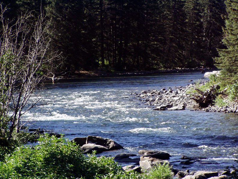
Gallatin River
Image
Reply

The final days of the road trip were by far the longest of the entire trip. Day 20 took me from West Yellowstone, MT to Medora, ND. This was nearly 520 miles and I had to be in Medora for the Musical at 8:30. I got going about 8:30 and it was a nice drive north out of West Yellowstone, which actually took me back into Wyoming and through the edge of Yellowstone NP. The route followed the Gallatin River which was really nice, I saw lots of fly fishermen along the way.
At Bozeman, I connected to I-90 and the pace really picked up. Most of my driving the last three weeks has been on older US highways or state highways and you just can’t drive that fast, Interstate Highways rock! I hadn’t planned to stop anywhere along the way, but saw a sign for Pompeys Pillar and checked my map to confirm that it was right next to the highway so figured I could use a short break from driving. I had no idea what it was, but it was a national historic site, so what the heck.
Turns out, Pompeys Pillar is a big rock in the middle of the plains that Native Americans had known about for awhile. William Clark (of Lewis and Clark) came across it in July of 1806 and carved his name on the rock. It’s pretty much the only visible evidence left anywhere of the Lewis and Clark expidition. A new visitor center just opened Memorial Day this year.
From there it was on to Medora and I made it there by about 5 o’clock. Got my tent set up and then took a quick tour through part of the South Unit of Theodore Roosevelt National Park. Lots of prairie dogs and beautiful scenery. I couldn’t spend too much time though as I had to be back in Medora for the show. I got there about 8:00 and as the sun was going down, the temperature dropped nicely and it was a perfect night to see the show.
The featured act for the entire summer is a group of acrobats from Kenya. It’s seven guys and they do some pretty amazing things. One of the highlights was the flaming limbo bar placed atop two Coke bottles! The other act was a comedian from New York and he was quite funny.
Saturday was the last day on the road and was scheduled to be just over 570 miles – a long day! However, I had gotten an e-mail from my mom earlier in the week saying that my grandpa was not doing too well. It’s been quite awhile since I’d seen him and since I wasn’t too far away, I though I should make a detour up to Tioga. I made it up there just before noon (would have been earlier, but those darn time zones work against you when you’re travelling east). I spent about an hour with him and then was on the road shortly after 1. So the little detour added about 240 miles making this by far the longest day of the trip. After over 800 miles and I don’t know how many hours, I pulled into my garage at midnight. Good night!
On-line access is too slow to post all the updates to the website from here, so it’s just the blog until I get home. Enjoy.
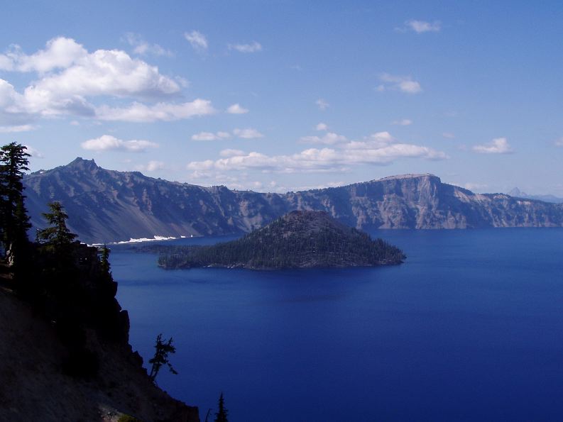
Wizard Island in Crater Lake
As hoped with the adjusted schedule from yesterday, I was able to get rolling just after 7 this morning which got me to Craters of the Moon National Monument just after 9 in the morning which was at least two hours earlier than if I had camped in Mountain home as planned.
Craters of the Moon is an area of the Snake River Rift valley. This region was formed as the continental crust drifted over a hot spot in the mantle. Yellowstone is currently over this hot spot, hence all of the geological and geothermal activity there.
The entire region is covered with cinder cone volcanoes of various ages and sizes and lava, lots of lava. Everywhere you look there is lava of one sort or another. There are even lava tubes that have opened up and are now caves. A few of which you can get into and explore. I just went through the biggest (and quickest) as I didn’t want to spend the whole day here – though I easily could have. All in all it’s a pretty interesting place.
As this was really just a travel day and CotM happened to be along the way I wanted to stop. But after three hours it was noon and I had seen most of the highlights of the park, so it was time to roll again.
I got back on the road headed for West Yellowstone and my campground, but after only about 45 minutes I came across a sign advertising EBR-1 Historic site and since I had just entered an area designated as the Idaho National Laboratory, I was intrigued. I followed the sign down the road, only a mile out of my way, and found myself at EBR-1. That’s Experimental Breeder Reactor #1, the world’s first nuclear power reactor.
It first went online in 1951 and was decommisisoned in ’64 and is now a national historic site and you can tour the place. So I did. Pretty interesting stuff. The best factoid is that the word scram – as in to shut something (a nuclear reactor for instance) OFF quickly is an acronym. Seems the Manhatten project reactor had a sophisticated emergency system – a guy with an axe would cut a rope which would release a control rod into the nulear pile. Hence; Safety Control Rod Axe Man – or SCRAM.
I’m always amazed at what sort of things our government and military were willing to consider during the Cold War – especially the early years. Turns out there was serious investigation into developing nuclear powered…
wait for it…
Aircraft!
They actually went so far as to build actual test engines. The idea never went too far, they realized advancements in conventional jet engines were surpassing their experiment. Not to mention the safety concerns about nuclear reactors flying around and possibly crashing or being shot down. Of course they did crash one or blow it up or something to prove that it would be safe. I feel safe, don’t you?
After about an hour there, I saw all there was to see and headed off for some lunch and the rest of my day’s drive. I made to West Yellowstone and one of the nicest KOA campgrounds yet. It would be perfect if the WiFi worked at my actual campsite, but that’s the only complaint. Not too bad since I’m supposed to be camping!
This morning wasn’t as cold as yesterday, I think it stayed in the 40s overnight. I rolled out of the tent around seven and had everthing wrapped up and ready to roll by nine. It was another 15 minutes before I got on the road as I had to stop and talk to a guy about my car as I walked out of the gas station. I’ve only seen one other Solstice during my entire trip so far, but I’ve had lots of people stop and ask me how I like it and just to have a closer look:-)
Today was another driving day, planned from Crater Lake to Mountain Home, Idaho. This was the longest planned day at almost 460 miles. Eastern Oregon is mostly rural and there are not any direct routes east to west in the southern half of the state, which is where Crater Lake is located. So it was a slow drive through Oregon, though the scenery was OK.
I stopped in Burns for lunch and had a look at the rest of today’s trip and checked tomorrows. Tomorrow’s trip was longer than I remembered, so I decided to change things up a bit. I decided to drive an extra 60 miles today and stop in Gooding, ID instead of Mountain Home. This is 60 miles I don’t have to drive tomorrow and I also opted to stay in a motel tonight, which will save me about 2 hours in the morning, which is what it normally takes to break camp. That will get me into West Yosemite earlier than planned, so I may be able to take a run through Grand Teton or a look at Old Faithful. Time will tell.
Monday was another driving day, this time from Eureka, CA up to Crater Lake National Park in Oregon. I got going a bit late as I felt like sleeping in, so I was on the road at 10 o’clock.
The drive north out of Eureka took me back through Redwood National Park and a number of California State Parks, also dedicated to Redwood preservation.
I pulled into Crater Lake NP around 4 o’clock and had planned on camping, but I thought I would run up to the Lodge just to see if they had any rooms available as I am getting a bit tired of sleeping in a tent and thought it would be cool as the lodge sits on the rim of the caldera, which offers an excellent view of the lake.
But the there was no room in the lodge, so I went down to the campground and found a site to my liking. For the first time during the whole trip, I had to break out the bug spray as there were a few too many mosquitos. I got settled in, made some dinner and then went and listened to Ranger Karen give a talk about Lions, and Tigers, and Bears, Oh my! On the way back to my tent I happened to look up and noticed it was an absolutely clear night, the stars were amazing as the sky around hree is quite dark. Then I crawled into my tent for the night.
I woke up this morning (Tuesday) about 5 o’clock and was freezing. Last night the temperature had been in the mid 60s which is typicaly for Crater Lake, they say they have two seasons here; winter and August. By the time I crawled out of my tent at 7 it was still freezing. I didn’t feel like making breakfast in the cold, so I went to the camp restaurant and ate there and more importantly warmed up. I rolled out of there about 8 and it was finally a decent temperature and seemed to be warming up.
My plan for the day was to take the scenic rim drive from the south side of the lake to the north side and catch the boat tour of the lake. After that a hike up Scott Peak to view the entire park. I got up to the north side of the lake shortly after 9 and secured the last ticket on the first boat out, which also included a two hour stop on Wizard Island. From the parking lot it’s just over a mile hike, about 700 ft down the caldera wall to the boat dock. This wasn’t so bad, but of course the reverse is required to get out.
The tour started with about a half hour ride out to Wizard Island, with a few stops to point out some of the geology of the caldera. Wizard Island is a cinder cone volcano within the lake and it rises about 700 ft above the water surface. So that’s what I did, hiked all the way up, took some pictures, and after decending into the crater I hiked back up and then back to the boat launch. That pretty much killed the two hours. The other option was just to hike around the lake to a bay and look at some rocks, which didn’t sound too interesting.
On the way up the crater, I met a guy from St. Paul who teaches Earth Science at Humboldt Junior High. He hadn’t been impressed with all of the ranger’s geology explanations, but oh well. He did inform me why I had been so cold this morning – it was between 34 and 36 degrees!
After Wizard Island, there was about another hour on the boat with some more interesting information and great views. Then it was time to climb out of the caldera. It took about a half hour, which wasn’t too bad, but by this time it was already 2:30 and I was beat. The Scott peak hike was five miles round trip and I decided that would have to wait for another visit. Instead, I completed the rim drive loop and then drove out to an area called the Pinnacles. The Pinnacles are another geological formation due to the volcanism in the area. Basically, they are the remains of vertical lava tubes which have been exposed by the erosion of a river. I snapped a couple pictures, but I was so tired I then took a nap in my car before heading back to camp.
Bottom line, another wonderful National Park!

View from somewhere along the Shoreline Highway between SF and Eureka
I’m hanging out in Eureka, CA this weekend. On Friday I drove from Yosemite over to San Francisco and was able to visit Claus and Ingrid and meet their new baby, Markus. I think this was the first time I had seen them since their move to SF, so it was great to hang out with them again. After driving through some of the most desolate parts of the country during the last week, the congestion of the bay area (even at non rush hour) was a bit of a shock!
I drove up the coast Saturday morning from Petaluma (just north of San Francisco) and arrived here about 6 in the evening. It was a nice leisurely (slow and winding) drive up the Shoreline Highway (California 1).
I had woken up to an apparently typical foggy/misty/drizzly morning in the bay area and was not looking forward to breaking camp with everything being wet. I hung out in my tent for about an hour, watching an episode of SG-1 (portable DVD playerslaptops are awesome!), and by that time things had dried out enough to make it bearable.
By the time I hit the road, about 9 a.m., it was stilly cloudy and not very pleasant. By about 11, I had gotten far enough north andor the sun was finally able to burn off some of the cloudsfog and it turned into a beautiful day on the coast. My car is a blast to drive on all of the curvy, steep roads I’ve been on for the last week or so!
It had been pleasantly cool along the coast, around 80, in the bay area, but here in Eureka, it was even cooler – only in the upper 60s but with clear blue skies and down to the upper 40s at night. It’s fantastic!
This morning, Sunday, I drove up to Redwood National Park which is about 45 minutes north of Eureka. The trees here are the Coast Redwood, which are related to the Giant Redwood (Sequoia) that I saw in Yosemite. While the Giant variety is the largest overall (volume) tree, the Coast variety is the tallest, by at least 50 feet, but only about half as big around. These things are just enormous. The Coast variety is just as limited in its range as the Giant. It only grows in an area about 450 miles north to south and about 25 miles wide and below an elevation of 3000 feet. Also, unlike the Giant variety, the Coast Redwoods were heavily logged. Of the 2 million acres of Old Growth forest that were present when white folk arrived, only about 100,000 acres have now been preserved in state and national parks. They are still being logged today, but at least there are now areas where recovery is occurring.
Most of Redwood Park is only accessible via unpaved roads, so my visit there was fairly short. But, to be honest, once you’ve seen one humongous tree, you’ve kind of seen them all. It’s definitely something to see though. So after a quick hike I headed back to the camp to do a load of laundry and just relax. I’m on vacation but I’ve been going steady for two weeks and realized I need a day to just sort of hang out. This is a great place for it as the weather is perfect – it’s 68 degrees and sunny with a nice breeze blowing in off the ocean – my campground is just off of Humboldt Bay, which is separated from the ocean by just a narrow strip of land. I feel for all of you back in the midwest with the near 100 degrees – but you do have AC so it’s not that bad!
I hope to have my website all caught up this evening as that’s how I’m actually relaxing. This is the first chance since I left Yosemite to work on it and the next few days I won’t have internet access in order to do any updates.
I spent the morning in the Mariposa Grove of Giant Sequoia. These are the largest organisms on the planet. There are trees that are taller, and there are trees that have larger trunks, but these have the combination that provides the largest volume. They are ginormous!
What I thought was going to be a quick jaunt through the forest to look at a couple of trees, turned into an all morning, something like 6 mile hike. It was worth it though as I made it to Wawona Point overlooking Wawona Valley. Pretty nice view.
From there I headed over to the Glacier Point drive and stopped off to hike the Sentinal Dome. That was just a leisurely 2 mile hike to the top of Sentinal Dome, and oh boy, was it ever worth it! Sentinal Dome is on the south rim of Yosemite valley and gives you a panoramic view of the entire valley and the surrounding Sierra Nevada mountains. This is the place to see it all. I could have spent all afternoon there, but nature calls, as it were…
I finally made it out to Glacier Point and what do you know, more great views. From here, the only major feature not visible is El Capitan and since it’s lower down the valley wall then the Sentinal Dome, the surrounding mountains aren’t visible, but spectacular shots of Half Dome are easily had.
By this time, it was 4:30 and time to start the drive back to the campground. Yosemite is such a huge park, 1.2 million acres, at least 6 separate entrances and seemingly endless possibilities. This is definitely someplace everyone should see and I’ll definitely be coming back. I want to hike to the top of Half Dome, but didn’t have the time on this short visit.

Yet Another Site
News and notes from the Grand Forks Herald's Brad Elliott Schlossman
