The Great River Road Trip 2025 – Day 10

To be honest the last couple of days have been a slog. A couple of long boring days on the road, highlighted only by the visit to the Vicksburg National Military Park. Today’s plan is to get to Alton, IL, just on the north side of St. Louis – on the Illinois side of the river of course.

Just a few blocks from the hotel I stayed was a Cracker Barrel, so since I missed it yesterday, that’s where I started my day. Was a good choice to take some time since it was raining quite heavily and would rather avoid driving in that. So had my breakfast and filled up with coffee and the rain had stopped. Topped off with gas and was on my way. Dang it – that’s twice now I’d forgotten to clean my windshield!

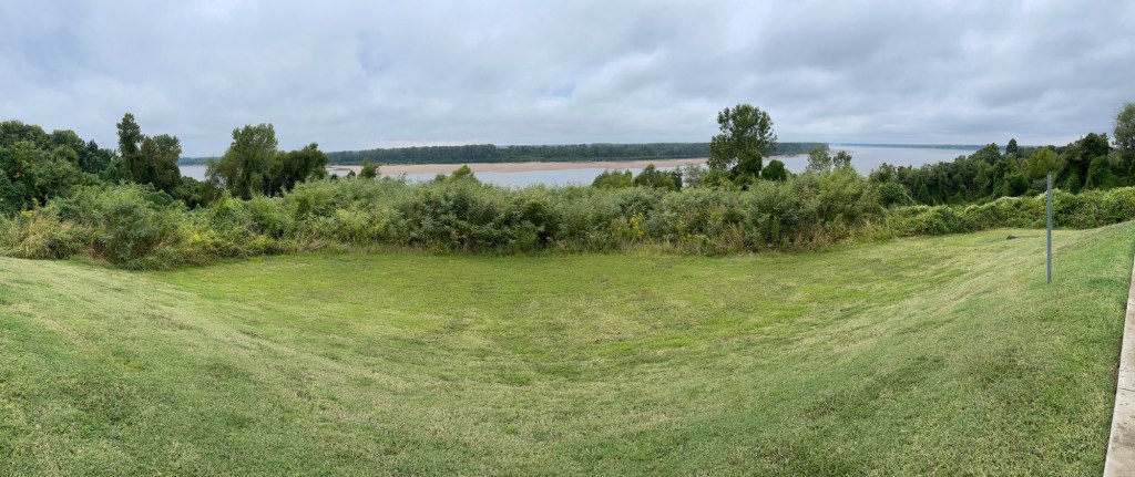
Coming into Dyersburg yesterday I had by-passed the actual route about 15 miles south of town as I wanted to get settled in. So the drive started with a bit of backtracking to the south to get back onto the Great River Road. So worth it! I think. It was backroads along the levee and across a bayou, but the views were obstructed for a portion as it started raining again. Heavily! Good news – my windshield is nice and clean!

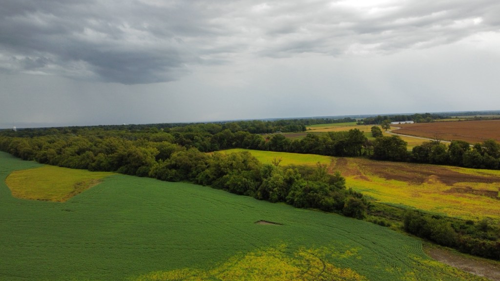
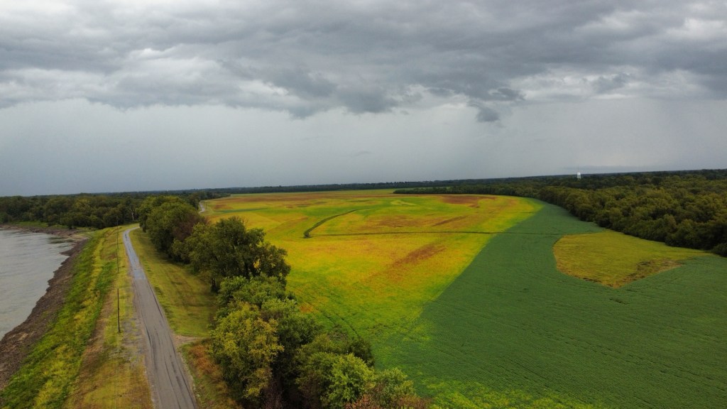
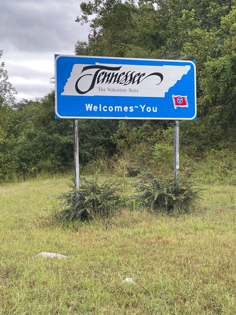
Was a nice drive through this portion of Tennessee and there was a nice pull over at a ferry crossing and the rain had stopped for a few minutes. I took the opportunity to fly the drone and get a few shots. From there it was onwards toward Kentucky.

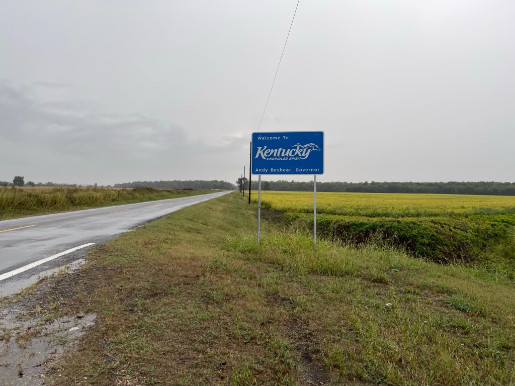
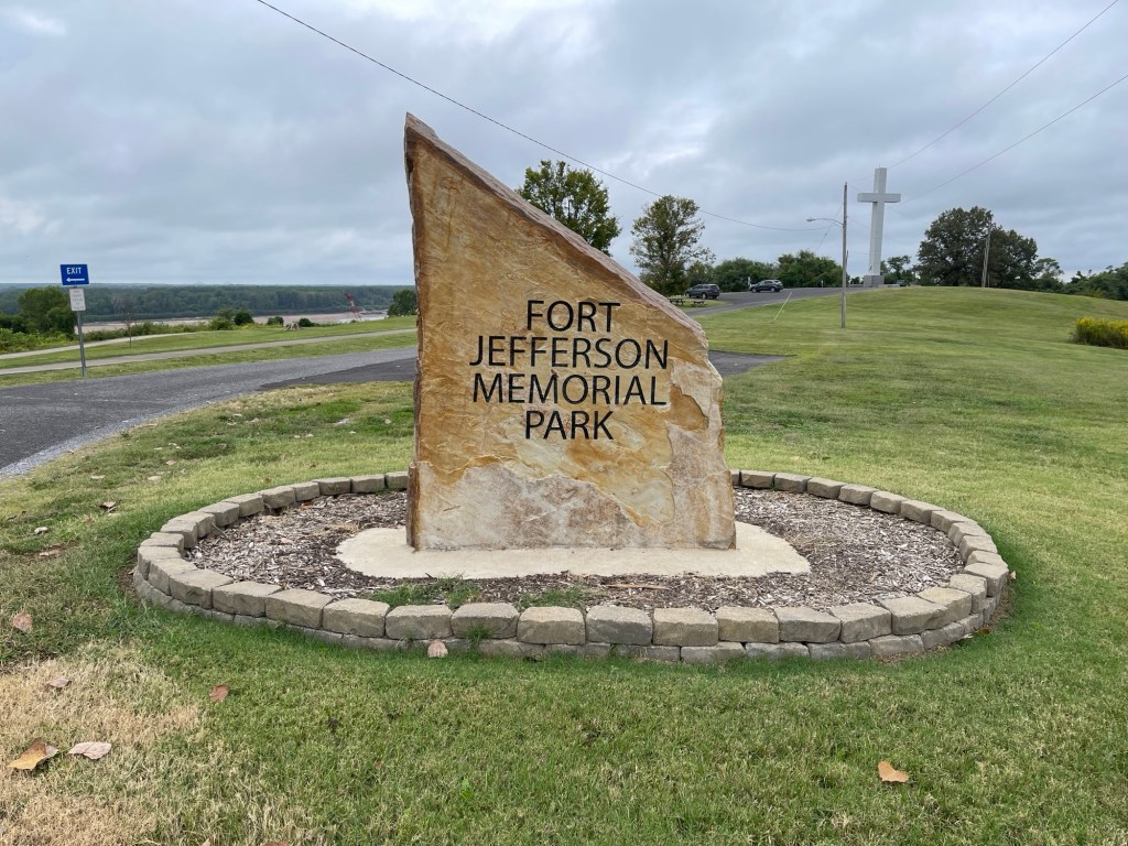
The route entered into Kentucky and presented a lot of nice roads and scenery. It’s quite a short section of the route through the western tip of Kentucky but worth it. I stopped at a scenic overlook in Wickliffe, KY that was the site of the Revolutionary War site called Fort Jefferson. I actually had no idea, or at least recollection, that there was any related activity this far west during that war. But it turns out there were several battles\skirmishes with American victories that led to the US acquiring these territories in the treaty that ended the war. Know you know!

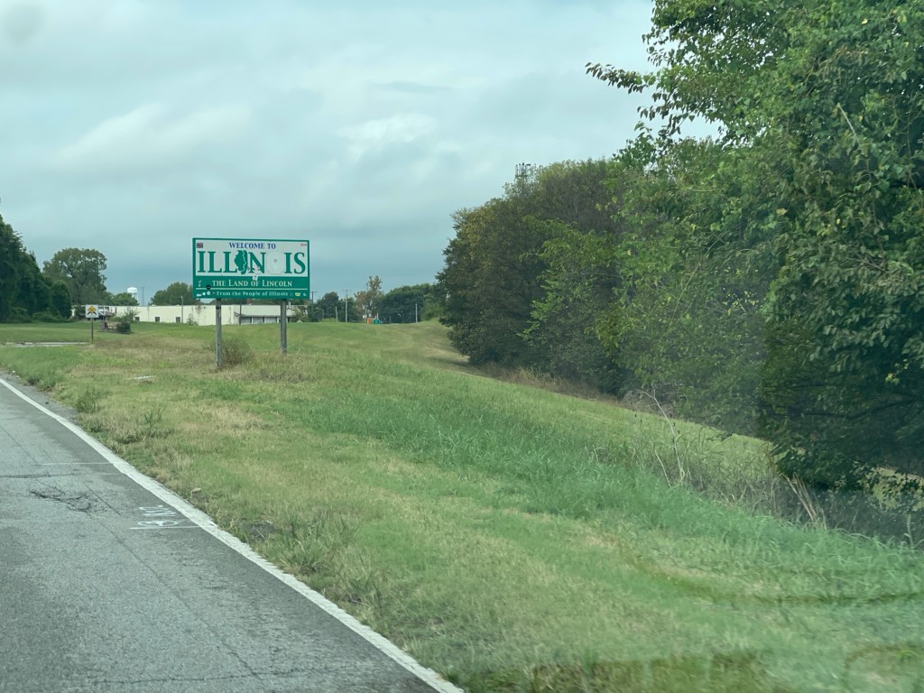
Shortly north of Wickliffe, the route crosses the Ohio river into Illinois and the town of Cairo – namesake of the U.S.S. Cairo mentioned yesterday from the Vicksburg National Military Park. From here I would follow Illinois state highway 3 all the way to the southern edge of St. Louis. Highway 3 offered a lot of nice scenery and was a good drive. Highway 3 would continue directly through East St. Louis. however as it was getting late in the day and was pretty much rush hour I had no idea how long it would take to go through. Therefore I opted to take the Interstate around East St. Louis. Made it to the hotel in Alton about 5pm, so it had been a good 8 hours on the road with only a couple of quick breaks along the way.

After settling in at the hotel I did a little sleuthing for someplace to eat in Alton and came across The Old Bakery Beer Company. It’s a casual craft brewery with lots of good selections and an interesting menu. I tried their Golden Oat and Dreamin’ for a Cure beers and both were amazing. For eats I had their Harvest Grain salad which was also delicious! From there back to hotel to write this up and crash!

Today was a much better day on the road and I think the next two should be good as well so long as this side of the river corresponds well to the western side of the first couple of days.

The Great River Road Trip 2025 – Day 9

Today’s drive took me from Vicksburg, MS to Dyersburg, TN. Was a little trouble getting on the road… Left the hotel early as I was just going to stop somewhere on my way out of Vicksburg and also top off with gas. Initially went wrong way out of the motel parking lot and so had to backtrack a bit to get back on US-61. No big deal. Got on the road and then saw a sign for a Cracker Barrel and as I hadn’t been to one of those in ages, I thought perfect. Took the exit, sign says one mile straight ahead. OK, farther than I wanted, but no big deal. One mile, no Cracker Barrel, two miles nope, 3 miles? OK, screw it I had a big dinner last night and wasn’t all that hungry anyway…

Backtrack, see the sign for the shared US-61\I-20 that I just came off of, great. Oops, not so great they split there I just got on I-20. Son-of-a… Six miles later, turn around, backtrack, ok back on good ol’ US-61! Little annoyed at this point, gotta stop for gas. Oh, I’ll get the next one.

Uh-oh. Again, my lack of planning bits me a bit. Once out of Vicksburg, there is a whole lotta nothing in the northwestern part of Mississippi. The route headed north for a ways and then split off of 61 to a road that parllels the levee. Looking at my remaining mileage, the distance to go and the lack of any significant towns got me a bit nervous. I decided I would stay on 61 as I was certain I’d make the next town with gas that way so I skipped the turn for the real route. Fortunately, just six miles later I hit a gas station. Topped off, and backtracked (again) to get the turn to follow the Great River Road. Glad I did as the backroads were nice. And it turns out I could have made it to a gas station on that route too, but better safe than sorry.

After that it was a more or less routine drive the rest of the way out of Mississippi. But finally some hilly, winding roads for a bit. Crossing the border into Tennessee brought me shortly into Memphis. The route zig zags through downtown Memphis and by either the third or fourth sign I lost track of the signs and the list of turns that I had jotted down, so I eventually I just decided to head north out of the city and find US-51 which would take me the rest of the way to Dyersburg. US-61 joins I-55 and crosses over to Arkansas at Memphis. Leaving Memphis, the Great River Route leaves US-51 for some backroads nearer the river, however as it had been raining most of the day, I opted to just stick with US-51 all the way to Dyersburg. About three o’clock I finally decided I’d stop and grab something to eat since I skipped breakfast. Found a nice BBQ place outside of Munford, TN called Outlaw BBQ. Had their pulled pork with a spicy sauce along with green beans and cole slaw. Taht was tasty!

A Night at the Opry

I’m in Nashville this week for work.  Had the evening free so thought I’d head over and see if I could get a ticket to the Grand Ole Opry.  I was in luck, got a seat about 10 rows back then went and had some BBQ at Mission BBQ before the show.

Larry Gatlin and the Gatlin Brothers opened the show – they still sound great!

Larry Gatlin

Performances followed by:

Scotty McCreery – winner of American Idol Season 10

Bill Anderson

Craig Morgan

Jon Pardi

RaeLynn

Chase Bryant

and

Brad Paisley who then brought out a special guest – John Fogerty!  Amazingly, this was John Fogerty’s first performance at the Grand Ole Opry, what a treat!

Day 4 – Great Smoky Mountains NP

So, my plan called for one more night at the park, but I changed it up a bit after reviewing my plan for today and Thursday.  Instead of taking a drive through the park and returning to the campground and somewhat retracing my route tomorrow, I decided to just head for Georgia today.  I took the drive along the New Found Gap road, which connects the Tennessee side of the park to the North Carolina side.  Along the way was a side road up to Clingmans Peak which is the highest peak in the Smokies and the third highest east of the Mississippi.  Unfortunately, it was a very “smoky” day in the mountains, so the visibility was quite limited.  But still worth the hike up to the top.

DSC01346

After heading south out of the park, the big decision was where to spend the night – I was supposed to be in the park still.  I debated between campground and hotel and had nearly made up my mind to camp when it started to rain.  OK, a hotel sounds great!  So, I’m spending the night in Gainesville, GA, a little less than an hour north of Atlanta.  This will make what was going to be a long Thursday drive into only a four hour drive, so I may spend a little more time at Stone Mountain – depending on how the weather cooperates.

Day 3 – Great Smoky Mountains NP

Today I spent touring the Cades Cove area of the park – which is where I’m camping.  A “cove” here in the Smoky Mountains is essentially just a valley between two mountain ridges.  This area was first settled around 1820 – of course the Cherokee hunted these lands long before, just didn’t live in the area.  Interestingly, Great Smoky Mountains NP, is the only park (or one of very few at least) that was created out of almost entirely privately owned lands – most other parks were originally government owned land.   There are a few historic buildings (farms and churches) along the route, but given the volume of traffic on this route and the very limited parking areas, I didn’t visit any of those.

DSC01334

Instead, I hiked out to the falls on Abram’s Creek.  It’s about a 5 mile hike round trip that takes you through the woods along the creek and eventually down to the falls.  I’ll post some pictures in the next few days.

That was all the excitement I could handle for the day – I got back to my camp and did a little reading.  I’m currently reading “A Walk in the Woods” by Bill Bryson – which is a story of his travels on the Appalachian Trail.  I’ve read a couple other books he’s written and, as usual, this one doesn’t disappoint.

Day 2 – Driving

Well today was a driving day just getting over to Great Smoky Mountains NP.  It was about a six hour drive which was mostly uneventful.  The only excitement came about half way when I noticed some dark clouds along with a few flashes of lightning up in front, but off to the north of my route.  I was planning on stopping for gas and lunch anyway so wasn’t too worried.  I was driving with the top down though, so I did want to get there and put the top up.

I can now honestly say that, at speed in the rain (at least a little), you will still stay dry with the top down.  That’s right – I got rained on and stayed dry without a roof!  It may have been just the leading edge of the rain and a few stray drops, but the outside of the car was completely wet and there were maybe two drops on my seat when I pulled under a gas station canopy a minute later in London, Kentucky.  This was perfect timing however, as I stepped out of the car and started to pull the top up, the sky let loose and for about 30 seconds there was a torrential downpour.

From there I drove the rest of the way with the top up.  I arrived at my campsite about 6 this evening and got my campsite setup.  I’m staying at Cades Cove campground which is at the eastern end of the park.  There’s an 11 mile scenic loop drive that I’m planning to take tomorrow along which there is a short hike to a supposedly nice waterfall.

Time to hit the tent…