​ A day at Pearl Harbor

There was a lot more to see at Pearl Harbor than I expected…

I arrived at the visitor center at about 8:30, picked up my ticket (I took a 10am ticket instead of the one I reserved at 9 since there was lots to see up front). I took the guided audio tour and wandered around the visitor center until it was time to get in line for the movie and boat ride out to the Arizona memorial.

The Arizona tour wrapped up by 11 so I decided to take the tours of both the USS Bowfin (submarine) and the USS Missouri (battleship).

The Bowfin is a WWII era diesel electric sub that was nicknamed “Pearl Harbor’s Revenge”(or something like that) as she sailed on December 7, 1942 – one year after the attack. She sank 40+ enemy vessels during the war and during multiple deployments her crew suffered nothing more than a broken leg. Very lucky considering that the entire sub fleet lost nearly 20% of its boats during the war.

From there it is was on to the “Mighty Mo”. Coming out of the cramped quarters of the Bowfin, it’s hard to comprehend just how big the Missouri is. Where the sub basically has one passage down its center, this place is like a maze. Here the captain has three cabins in various parts of the ship, the largest of which has a sitting area and a dining area that looked to seat at least a dozen people.

20130211-080400
I wrapped up at around 3pm and rather than trying to squeeze in a visit to the Air Museum of the Pacific; I opted to go ahead and head to the airport for my flight over to Hilo as I was pretty well beat. Tomorrow is a visit to Volcanoes National Park on the big island of Hawaii.

Aloha

I arrived in Honolulu just as the sun was setting. It’s been a long day to get here – left the house at 9 am and it’s now 12:30 at home. Only 8:30 here on the island;-).

Grabbing dinner at the hotel and then gotta hit the sack. My Pearl Harbor tour is scheduled at 9 tomorrow morning.
20130209-203520
A view from my balcony.

​Relieved to be on Vacation!

It was a very close call getting out of Boston before the storm yesterday. A short time after closing the door they reopened it for “updated information”. Lots of people wondering if that meant cancelled – turned out to be a straggler getting on board.

After leaving the gate we had to be de-iced and only then did we taxi out to the runway. Then, a first in my experience, the co-pilot actually came into the cabin to have a look at all the flight surfaces. Then they got updated reports on the condition of the runway. Finally they throttled up the engines and we were off. Only then was I sure I was headed for Hawaii;-).
We were the last flight out of Logan and there was not a single plane left on the ground. Kind of an eerie experience.  Anyway, I’m just sitting in the plane getting ready to take off on the first leg of my trip. Next stop – LAX.
Updated
14:34 PST – Reboarded the plane after 1 and a half hour layover at LAX. First offering on board – Mai Tais; welcome to the tropics!

Escape the Snowpocalypse!

So I was in Providence, RI this week and scheduled to fly out of Boston this evening. Really need to make it as my flight to Hawaii is tomorrow morning. Wouldn’t ya know the biggest storm in about 35 years is heading this way… Here we go:

Step 1 – change flight to an earlier one. Check.
And thanks to Delta for waiving the change fees! My original flight for this evening was already cancelled last night.
Step 2 – check flight status at least hourly. Check.
Step 3-15 – repeat step 2. Check.
Step 16 – Drive to Boston. Check.
Snow just starting in Providence when I hit the road. Very strange feeling in Boston – the least traffic I’ve ever seen here and airport is very quiet. As of 10:30 there is a light but steady snow falling…
Step 17 – wait and hope things hold out for a couple more hours. Updates to come…
20130208-103507
Step 18 – Get on board. Last flight out before the airport shuts down. Check!
20130208-141947
Step 19 – in my seat and ready to go. Check!
20130208-143242
Step 20 – De-ice, taxi to runway, have co-pilot examine wings, get report on runway condition, spool up the engines and roll. Wheels up. Check.
Step 21 – exhale.
20130208-201219

Vacation Time

So I’ve been convinced to join Jerry and Liz & John at their time-share in Hawaii! I’m going to first fly into Honolulu on Saturday February 9th and visit Pearl Harbor on Sunday. I haven’t decided yet whether to hop over to the big island Sunday evening and visit Volcanoes National Park on Monday before joining them on Kaua’i or hit that later in the week for a day. Will get that figured out in the next few days…

Days 12 & 13: Driving Days

GOPR4527

The past two days have simply been driving days.  Yesterday was from Evanston, WY to Cheyenne and today took me to Omaha.  There was a bit of nice scenery coming through the mountains in WY yesterday but nothing like the sights driving I-70 through Colorado.  The only bit of mild excitement was when I ran over a chunk of tire just west of Lincoln this afternoon…

The passenger side wheel well was knocked loose and I found the marker light hanging buy it’s cabling.  I was able to pop those things back into place.  By the time I reached Omaha the tire was fairly flat.  I re-inflated it with the compressor and it seemed to be holding, but we’ll see in the morning.  If it’s low in the morning then I’ll use the sealant that I have and limp over to a tire store…

And for anyone whos ever wondered just what its like to drive across Nebraska, enjoy the following video.

Day 11: Cedar Breaks National Monument

I departed Cedar City for Cedar Breaks National Monument which was my last planned destination in Utah.  The direct route out of town was not an option as the road was closed due to a “massive rockslide”.  So the GPS thought I should take a dirt road over the mountain – uh, no thanks.  I kept going a bit further until I found the alternate paved road.  It was a fun drive that climbs about 5000 feet in about 20 miles.

DSC_0005

The Cedar Breaks is an isolated version of the same type of formation at Bryce Canyon.  It’s a single amphitheater that is about 2500 feet deep and 3 miles across.  It’s located at just over 10,000 feet and there is still snow present as seen in the picture above.

From there I headed up to Evanston, Wyoming where I’;m spending the night.  The plan was to head to Grand Teton tomorrow.  However, I knew from the beginning that the back half of this trip was going to be a bit dicey given the time of year and the locations.  Looking at the weather for the next few days in Grand Teton shows snow/rain mix which is not a good idea with the Solstice and a trailer.  It’s also forecast to be raining at Devils Tower.  So, I’m pulling the plug on both of those and just heading for home.  Probably to Cheyenne tomorrow, then Omaha and home on Friday.

Day 10: Zion National Park

This morning was a short drive over to Zion National Park – only about 90 miles.  I got on the road about 8:30 and after stopping to top off the tank just outside the park I hit the gate about 10:30.  Asked the ranger which campground was best.  His answer, “whichever one you can find a spot in.  They’ll likely be full in the next few minutes”.  That didn’t bode well.  Neither did all the traffic in front of me.

When planning this trip I had tried to reserve a campsite in Zion but there are only a limited number available for this.  Most are simply first come, first serve.  I was hoping that since I was arriving on a Monday, before noon, I would be OK.  There are two campgrounds in the park and as I approached the first, the sign at the entrance said “Full”.  Ditto for the second.  Uh-oh.

So I ended up at the visitor center and decided to hop the shuttle up the scenic route – no private cars allowed except during the off-season.  I got off at two stops, the first just snapped a few shots, the second took a 2 mile hike along the river to the “Narrows” where the canyon narrows to a slot.  From there it was back to the car and decision time.

DSC_0883

I have mixed feelings about Zion.  Without doubt it is one of the most beautiful parks, but it’s ridiculously crowded.  The campgrounds are in the bottom of the canyon near the visitor center and even today in late May it was very hot – hindsight I’m actually glad I couldn’t get a campsite.  The lodge rates were from $175-$200 a night – they had vacancies but I wasn’t going to pay that.  So I headed out of the park and of course all the hotels in the little town were filled.  I had decided by this time that I didn’t want to come back to Zion tomorrow as originally planned given all the crowds and the distance I’d likely have to drive.  So it was on to Cedar City which is near my next planned sight anyway – Cedar Breaks National Monument.  I put my Hilton Honors points to good use and am staying at a Hampton Inn tonight.  A nice break from the camping.  Besides it was awfully hot today…

I certainly want to come back to Zion as there are a lot of areas that I didn’t get to see and there are a number of hikes that I would like to do.  But given the crowds it seems like a visit here really needs to be in the off-season and more importantly needs to be a destination rather than a side trip as was the case this time.

Onwards!

Day 9: Eclipse Day at Bryce Canyon NP!

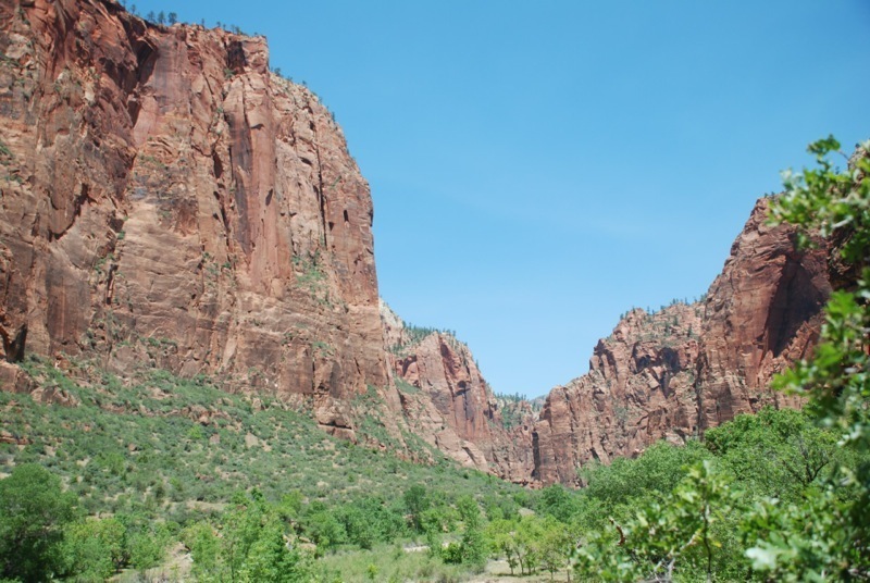
A beautiful day for an eclipse – clear blue sky and just a little wind!

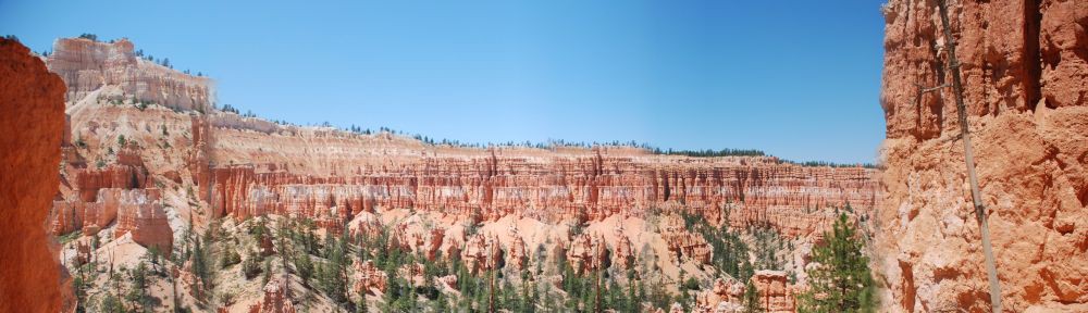
I started the day at the park by just driving up the scenic drive again, this time capturing it in real time on my camera to compare with the time-lapse that I took yesterday.  After that I parked the car at Sunrise Point and headed off to hike the Navajo Loop Trail.

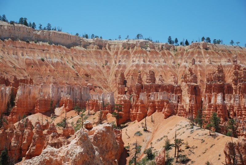
The Navajo loop is a 1.3 mile trail that goes down 0.6 miles and then back up 0.7 miles if you go in the clockwise direction.  Yesterday near the end of my 6 mile hike I took the 0.6 mile section up.  So today I went down that side and came back up the other way which I hadn’t seen yet.  On this leg which is called “Wall Street” the trail goes through a narrow slot canyon which makes for some spectacular views up the vertical walls to the open sky and also through the canyon looking at the switchbacks you have to climb to get out.  It took me about an hour to do this given all the photos I had to stop and take;-)

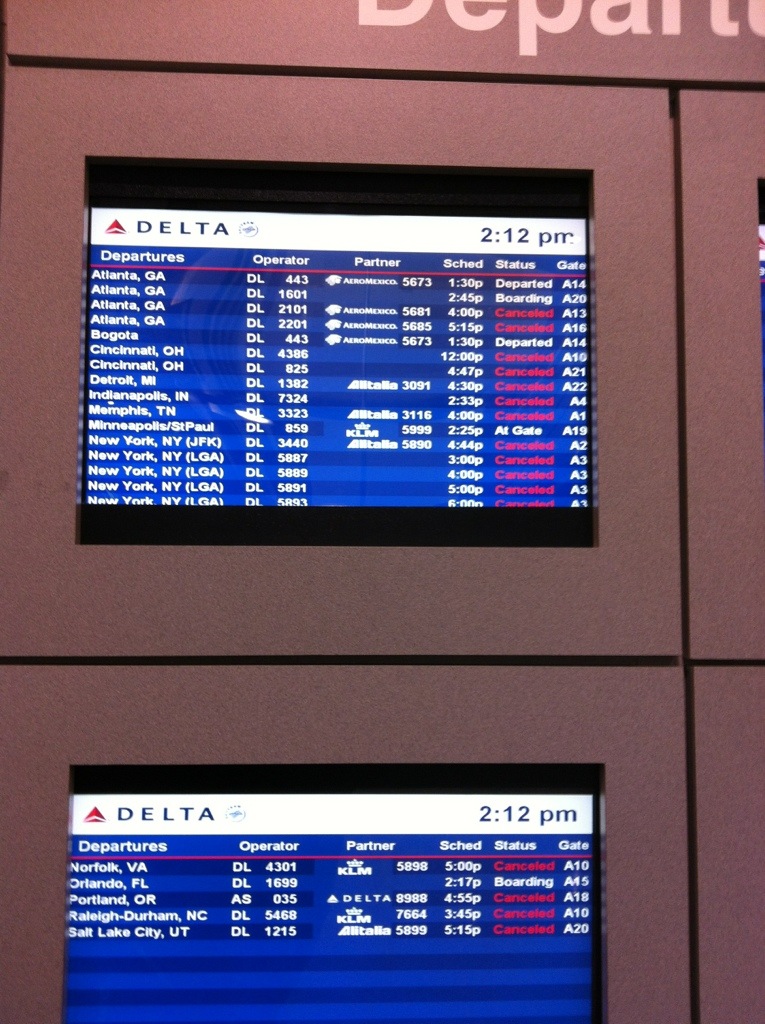
After that I headed to the Bryce Canyon Lodge and had a leisurely lunch.  From there I headed back to my car since I had seen enough of the canyon for awhile.  Just did a little reading and relaxing until about 3:30 when I headed down the road to grab a shuttle ride out to Bryce Point.  Turns out I should have taken that time to check my equipment – I had forgotten my tripod back at camp.  I was going to be forced to take pictures of the eclipse the hard way.

Made it out to Bryce Point about 4 pm and got myself situated right on the rim across from the Bryce Amphitheater.  There were hundreds of people at Bryce Point and I don’t know how many at the other sites.  Chatted with a nice couple from Eugene, OR while waiting for the show to start.  She’s French Canadian and he’s Czech and they had also lived in Owatonna, MN for awhile in the 80s.

DSC_0190

It took me a few tries to dial in the settings on my camera to get images of the sun (should have had a neutral density filter…) but I finally got as best as could be.  The sun was still too bright for about the first half – even though I could see through the eclipse glasses the transit, it still caused overexposure of the sun.  But as the moon got a bit more than halfway across the sun, I could start to see a crescent in my images.  Then at the maximum I got the image above.  I then continued snapping photos through the remainder of the eclipse – all the way to sunset.  I’m going to assemble a time lapse of this as well but unfortunately since I did this all handheld I’m going to have to crop a lot of images otherwise it’ll be jumping all over the place.

After that it was a bit of waiting for the shuttle ride back to my car (or close to my car anyway).  Not sure if it’s always so disorganized, they also had one bus break down, but I think I waited nearly an hour.  This was after also sitting through the entire eclipse – most people had headed to the busses just after the maximum.  Then it was back to camp and bed.  On to Zion tomorrow!

Day 8: Bryce Canyon National Park – Day 2

Last night was another very windy night and I didn’t get much sleep.  Fortunately the modifications that I made to the rain fly during the day yesterday did go a long way in keeping additional sand out of the tent – so at least I didn’t have that flying in my face all night.

Today I had planned to be just a hiking day, but I realized that I had missed two of the viewpoints during my visit yesterday – Yovimpa Point and Piracy Point.  So on returning to the park this morning I ran out to those two viewpoints and got some pictures.  Then headed down to Sunset Point to start my hike.

While yesterday was a more or less cloudy day with less than optimal lighting conditions, today was absolutely perfect.  The sky was clear with just an occasional lazy cloud and the most stunning shade of blue.

The hike I chose was actually a combination of three trails; Queen’s Garden, Peek-a-Boo Loop and Navajo loop.  These take you down into the Bryce Amphitheater so that you are down in and amongst the hoodoos.  The lower section takes you through a nice conifer forest.  The total length is somewhere around 6 miles.  The Navajo loop is the steepest section as far as I can tell and is completely uphill/downhill with no flat sections.  After making it up one side of the loop I had the option of going down the other side and back up again (1 mile total) – or just taking the remaining half mile back to the car – I chose the car.  I’m planning to do the rest of Navajo loop tomorrow morning as from the top it does look very interesting.

DSC_0305

The rest of tomorrow will be getting ready to view the eclipse which starts at about 6:20 MT and lasts about 2 hours.  I already have my snazzy eclipse viewing glasses!