Day 8 – Key West & Dry Tortugas, NP

So with the delay of the launch until Wednesday at the earliest, and there is a conflict that day with the launch of the Lunar Reconnaissance Orbiter (LRO), I have a few days to kill. Driving up to D.C. was out of the question given the distance, so I decided to head as far south as I could.

So, I’m in Key West – OK, not quite, as the campground is about 20 miles short of there.  But I’ll be heading over there bright and early tomorrow morning in order to catch the ferry for the day tour of Dry Tortugas NP.  It’s a small island group about 70 miles beyond Key West.  There was a fort there at one time and a tour is included with the trip.  I may do a little snorkeling as well.

I got here about 4:30 and wouldn’t you know as soon as I laid out my tent to set it up, a nice little thundershower passed through.  It only lasted about 10 minutes, but it was enough to soak the tent through since it was laying on the ground already.  Oh well, it’s nearly dry already, so it’s not the end of the world.  It’s also hot, of course, but there’s a fairly nice breeze blowing through occasionally, so hopefully it won’t be too bad.  I’m also hoping that being just 50 yards or so from the water will moderate the heat…

Day 4 – Great Smoky Mountains NP

So, my plan called for one more night at the park, but I changed it up a bit after reviewing my plan for today and Thursday.  Instead of taking a drive through the park and returning to the campground and somewhat retracing my route tomorrow, I decided to just head for Georgia today.  I took the drive along the New Found Gap road, which connects the Tennessee side of the park to the North Carolina side.  Along the way was a side road up to Clingmans Peak which is the highest peak in the Smokies and the third highest east of the Mississippi.  Unfortunately, it was a very “smoky” day in the mountains, so the visibility was quite limited.  But still worth the hike up to the top.

DSC01346

After heading south out of the park, the big decision was where to spend the night – I was supposed to be in the park still.  I debated between campground and hotel and had nearly made up my mind to camp when it started to rain.  OK, a hotel sounds great!  So, I’m spending the night in Gainesville, GA, a little less than an hour north of Atlanta.  This will make what was going to be a long Thursday drive into only a four hour drive, so I may spend a little more time at Stone Mountain – depending on how the weather cooperates.

Day 3 – Great Smoky Mountains NP

Today I spent touring the Cades Cove area of the park – which is where I’m camping.  A “cove” here in the Smoky Mountains is essentially just a valley between two mountain ridges.  This area was first settled around 1820 – of course the Cherokee hunted these lands long before, just didn’t live in the area.  Interestingly, Great Smoky Mountains NP, is the only park (or one of very few at least) that was created out of almost entirely privately owned lands – most other parks were originally government owned land.   There are a few historic buildings (farms and churches) along the route, but given the volume of traffic on this route and the very limited parking areas, I didn’t visit any of those.

DSC01334

Instead, I hiked out to the falls on Abram’s Creek.  It’s about a 5 mile hike round trip that takes you through the woods along the creek and eventually down to the falls.  I’ll post some pictures in the next few days.

That was all the excitement I could handle for the day – I got back to my camp and did a little reading.  I’m currently reading “A Walk in the Woods” by Bill Bryson – which is a story of his travels on the Appalachian Trail.  I’ve read a couple other books he’s written and, as usual, this one doesn’t disappoint.

Day 2 – Driving

Well today was a driving day just getting over to Great Smoky Mountains NP.  It was about a six hour drive which was mostly uneventful.  The only excitement came about half way when I noticed some dark clouds along with a few flashes of lightning up in front, but off to the north of my route.  I was planning on stopping for gas and lunch anyway so wasn’t too worried.  I was driving with the top down though, so I did want to get there and put the top up.

I can now honestly say that, at speed in the rain (at least a little), you will still stay dry with the top down.  That’s right – I got rained on and stayed dry without a roof!  It may have been just the leading edge of the rain and a few stray drops, but the outside of the car was completely wet and there were maybe two drops on my seat when I pulled under a gas station canopy a minute later in London, Kentucky.  This was perfect timing however, as I stepped out of the car and started to pull the top up, the sky let loose and for about 30 seconds there was a torrential downpour.

From there I drove the rest of the way with the top up.  I arrived at my campsite about 6 this evening and got my campsite setup.  I’m staying at Cades Cove campground which is at the eastern end of the park.  There’s an 11 mile scenic loop drive that I’m planning to take tomorrow along which there is a short hike to a supposedly nice waterfall.

Time to hit the tent…

Day 1 – Mammoth Cave NP

I didn’t follow my plan as well as I should have.  Because I wasn’t really tired, I ended up driving for nearly 10 solid hours to start off.  I finally pulled into a rest stop about 2 a.m. and slept for about two hours.  Then it was back on the road with a quick stop for breakfast.  Pulling the trailer, I’m keeping the speed down so the trip took a couple hours longer than I planned, better safe than sorry – plus it helps with the mileage!

After a little confusion regarding the time zone, I was able to take the Grand Avenue tour of Mammoth Cave.  This is one of the most extensive tours available, taking about 4 hours to cover approximately 4 miles underground.  This route includes scaling several underground “mountains”.  It’s a pretty amazing place – there are over 370 miles of cave in the network, but nobody really knows how much more might be connected.

DSC01299

After the tour, I hit the campground and got situated.  It’s cooling off now and is pretty comfortable, it’s about 7 p.m., but it was around 90 when I got started a couple hours ago.  At 8 I’m heading over to the amphitheater for a ranger discussion of myths and legends surrounding the cave area – should be interesting.

Updated 6/10 – so I actually fell asleep and missed the presentation thing – it had been a very long day.

Two long days on the road

The final days of the road trip were by far the longest of the entire trip.  Day 20 took me from West Yellowstone, MT to Medora, ND.  This was nearly 520 miles and I had to be in Medora for the Musical at 8:30.  I got going about 8:30 and it was a nice drive north out of West Yellowstone, which actually took me back into Wyoming and through the edge of Yellowstone NP.  The route followed the Gallatin River which was really nice, I saw lots of fly fishermen along the way.

At Bozeman, I connected to I-90 and the pace really picked up.  Most of my driving the last three weeks has been on older US highways or state highways and you just can’t drive that fast, Interstate Highways rock!  I hadn’t planned to stop anywhere along the way, but saw a sign for Pompeys Pillar and checked my map to confirm that it was right next to the highway so figured I could use a short break from driving.  I had no idea what it was, but it was a national historic site, so what the heck.

Turns out, Pompeys Pillar is a big rock in the middle of the plains that Native Americans had known about for awhile.  William Clark (of Lewis and Clark) came across it in July of 1806 and carved his name on the rock.  It’s pretty much the only visible evidence left anywhere of the Lewis and Clark expidition.  A new visitor center just opened Memorial Day this year.

From there it was on to Medora and I made it there by about 5 o’clock.  Got my tent set up and then took a quick tour through part of the South Unit of Theodore Roosevelt National Park.  Lots of prairie dogs and beautiful scenery.  I couldn’t spend too much time though as I had to be back in Medora for the show.  I got there about 8:00 and as the sun was going down, the temperature dropped nicely and it was a perfect night to see the show.

The featured act for the entire summer is a group of acrobats from Kenya.  It’s seven guys and they do some pretty amazing things.  One of the highlights was the flaming limbo bar placed atop two Coke bottles!  The other act was a comedian from New York and he was quite funny.

Saturday was the last day on the road and was scheduled to be just over 570 miles – a long day!  However, I had gotten an e-mail from my mom earlier in the week saying that my grandpa was not doing too well.  It’s been quite awhile since I’d seen him and since I wasn’t too far away, I though I should make a detour up to Tioga.  I made it up there just before noon (would have been earlier, but those darn time zones work against you when you’re travelling east).  I spent about an hour with him and then was on the road shortly after 1.  So the little detour added about 240 miles making this by far the longest day of the trip.  After over 800 miles and I don’t know how many hours, I pulled into my garage at midnight.  Good night!

Day 18 – Driving

This morning wasn’t as cold as yesterday, I think it stayed in the 40s overnight.  I rolled out of the tent around seven and had everthing wrapped up and ready to roll by nine.  It was another 15 minutes before I got on the road as I had to stop and talk to a guy about my car as I walked out of the gas station.  I’ve only seen one other Solstice during my entire trip so far, but I’ve had lots of people stop and ask me how I like it and just to have a closer look:-)

Today was another driving day, planned from Crater Lake to Mountain Home, Idaho.  This was the longest planned day at almost 460 miles.  Eastern Oregon is mostly rural and there are not any direct routes east to west in the southern half of the state, which is where Crater Lake is located.  So it was a slow drive through Oregon, though the scenery was OK.

I stopped in Burns for lunch and had a look at the rest of today’s trip and checked tomorrows.  Tomorrow’s trip was longer than I remembered, so I decided to change things up a bit.  I decided to drive an extra 60 miles today and stop in Gooding, ID instead of Mountain Home.  This is 60 miles I don’t have to drive tomorrow and I also opted to stay in a motel tonight, which will save me about 2 hours in the morning, which is what it normally takes to break camp.  That will get me into West Yosemite earlier than planned, so I may be able to take a run through Grand Teton or a look at Old Faithful.  Time will tell.

Day 17

Monday was another driving day, this time from Eureka, CA up to Crater Lake National Park in Oregon.  I got going a bit late as I felt like sleeping in, so I was on the road at 10 o’clock.

The drive north out of Eureka took me back through Redwood National Park and a number of California State Parks, also dedicated to Redwood preservation.

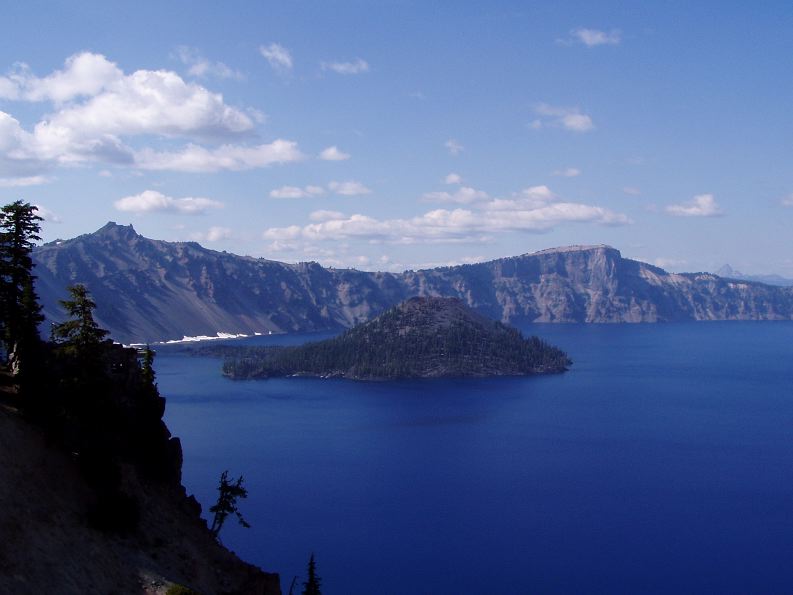
I pulled into Crater Lake NP around 4 o’clock and had planned on camping, but I thought I would run up to the Lodge just to see if they had any rooms available as I am getting a bit tired of sleeping in a tent and thought it would be cool as the lodge sits on the rim of the caldera, which offers an excellent view of the lake.

But the there was no room in the lodge, so I went down to the campground and found a site to my liking.  For the first time during the whole trip, I had to break out the bug spray as there were a few too many mosquitos.  I got settled in, made some dinner and then went and listened to Ranger Karen give a talk about Lions, and Tigers, and Bears, Oh my! On the way back to my tent I happened to look up and noticed it was an absolutely clear night, the stars were amazing as the sky around hree is quite dark.  Then I crawled into my tent for the night.

I woke up this morning (Tuesday) about 5 o’clock and was freezing.  Last night the temperature had been in the mid 60s which is typicaly for Crater Lake, they say they have two seasons here; winter and August.  By the time I crawled out of my tent at 7 it was still freezing.  I didn’t feel like making breakfast in the cold, so I went to the camp restaurant and ate there and more importantly warmed up.  I rolled out of there about 8 and it was finally a decent temperature and seemed to be warming up.

My plan for the day was to take the scenic rim drive from the south side of the lake to the north side and catch the boat tour of the lake.  After that a hike up Scott Peak to view the entire park.  I got up to the north side of the lake shortly after 9 and secured the last ticket on the first boat out, which also included a two hour stop on Wizard Island.  From the parking lot it’s just over a mile hike, about 700 ft down the caldera wall to the boat dock. This wasn’t so bad, but of course the reverse is required to get out.

The tour started with about a half hour ride out to Wizard Island, with a few stops to point out some of the geology of the caldera.  Wizard Island is a cinder cone volcano within the lake and it rises about 700 ft above the water surface.  So that’s what I did, hiked all the way up, took some pictures, and after decending into the crater I hiked back up and then back to the boat launch.  That pretty much killed the two hours.  The other option was just to hike around the lake to a bay and look at some rocks, which didn’t sound too interesting.

On the way up the crater, I met a guy from St. Paul who teaches Earth Science at Humboldt Junior High.  He hadn’t been impressed with all of the ranger’s geology explanations, but oh well.  He did inform me why I had been so cold this morning – it was between 34 and 36 degrees!

After Wizard Island, there was about another hour on the boat with some more interesting information and great views.  Then it was time to climb out of the caldera.  It took about a half hour, which wasn’t too bad, but by this time it was already 2:30 and I was beat.  The Scott peak hike was five miles round trip and I decided that would have to wait for another visit.  Instead, I completed the rim drive loop and then drove out to an area called the Pinnacles.  The Pinnacles are another geological formation due to the volcanism in the area.  Basically, they are the remains of vertical lava tubes which have been exposed by the erosion of a river.  I snapped a couple pictures, but I was so tired I then took a nap in my car before heading back to camp.

Bottom line, another wonderful National Park!