So I’ve been convinced to join Jerry and Liz & John at their time-share in Hawaii! I’m going to first fly into Honolulu on Saturday February 9th and visit Pearl Harbor on Sunday. I haven’t decided yet whether to hop over to the big island Sunday evening and visit Volcanoes National Park on Monday before joining them on Kaua’i or hit that later in the week for a day. Will get that figured out in the next few days…
Olympic National Park Redux
I was back in Seattle during the first week of October and decided to give Olympic National Park another go since my visit in June was a bust. Turns out this time of year is generally dry in the Pacific Northwest, so it worked out well.
New Blog Site!
With the latest updates to Mac OS X comes more changes to old things.
I updated to Mountain Lion when it was released this past July. As part of this, as advertised, the former MobileMe service was being discontinued and replaced with the new iCloud. This meant no more publishing to the Apple hosted site which I had used in parallel with my own server. That was really a non-issue for me. However, there are also some quirks with the iWeb software that I use to create my website and blog. They’ve become a bit too annoying to deal with while regularly updating the blog. I can deal with it for the occasional site update. My iWeb version is a couple of years old, and I could try updating but don’t really want to shell out the money since from what I’ve gathered on-line the latest release has the same issues.
Rocky Mountain National Park – Wild Basin
So I ended up “stuck” in Colorado over the weekend on a business trip. Fortunately Saturday was beautiful and I was free. Decided I’d head over to RMNP since it was less than an hour drive.
I know I should have checked the park website to see if there were any “conditions” to be aware of, but I got sidetracked on other things and never did… Driving towards Estes Park there seemed to be a lot of traffic, but I figured “it’s just a Saturday morning and it’s beautiful”. Then I saw the first sign indicating there might be an issue – something about only shuttle access into the park, uh-oh.
As I got closer, the traffic got even thicker and I saw another sign mentioning the shuttle. Then I hit Estes Park and it was a mad house! I turned around and headed back out of town and pulled over to do some investigation. OK, there is a major construction project to renovate the main road through the park. Only shuttle access between 9am-4pm. Expect delays of up to 2 hours! No thanks. Checked the map and decided to head to the Longs Peak area about 10 miles south.
That’s when I discovered the real reason for the traffic and crowd in Estes Park – Scottish and Irish Festival days, apparently one of the biggest of it’s kind in the country. Took me about another half hour to get thru town, but then I was finally free! Got down to Long’s Peak but given it was already about 10:30 the parking area was filled and the road down the hill was fully lined with cars. OK, plan C; a bit further south to the “Wild Basin Area”
Finally, no major crowds and parking only about 3/4 mile from the trail head, this’ll work! Finally got on the trail a little after 11 and made my way out to Ouzel Falls. The destination was a bit underwhelming but the journey was worth it. The day was clear and cool with a nice breeze – absolutely perfect for a stroll through the mountains! On the way back to the car, I decided to take an alternate route based on the park map I had. It looked only slightly further than the route I had gone in on.
A topo map would have been helpful. Turns out this route took me up the valley that I had come in on which was great for the views, but I wasn’t prepared to keep going up… It was worth it in the end – or what I thought was the end. I reached a distance marker at one point expecting it to be a bit less than a mile further to the car. Turned out to be almost 2.5 miles! Oh, well. I finally made it back to the car around 5 and was beat! Checked the map and plotted a course around Estes Park and was back to the hotel around 6. Time to relax!
Olympic National Park
So I had spent the week in Seattle for work and decided to spend the weekend and take the opportunity to visit Olympic National Park. It’s a large park, so I knew I was only going to be able to get a small taste, but that’s OK.
So after having 3 absolutely beautiful days during the week, spent inside of course, it got cloudy on Friday morning and was raining by the afternoon. I debated changing my flight and just heading home, but ended up deciding to take my chances (which I knew to be slim to none – OK, none) and drove over to Bremerton. I took the route over the Tacoma Narrows, which was the site of a pretty spectacular bridge failure in 1940 – the current spans were opened in 1950(westbound) and 2007(eastbound). My drive was uneventful!
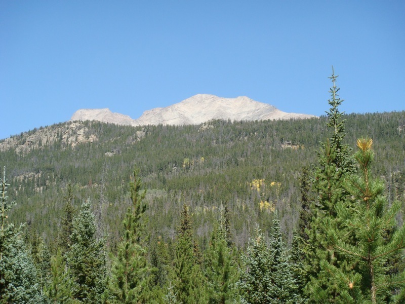
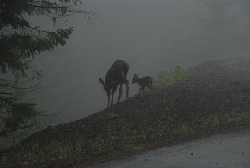
I woke up Saturday morning to a spectacularly cloudy, drizzly day but headed out to the park anyway. I stopped in at the visitor center and watched a nice 20 min film about the park and then headed up to Hurricane Ridge. This is a 17 mile drive up into the heart of the park, which on clear days would provide nice views of some of the mountains. On this day however, by the time I made it up to about 5,000′ the fog was pretty thick and at the visitor center at 7,000′ visibility was pretty much zilch! On the way down again I spotted a mother elk and very young calf and managed to pull the car into a turnout and jump out of the car in time to snap a couple pictures before they headed downslope.
From there I headed over to the Sol Duc Valley where I planned to take a short hike out to a waterfall. On a nice day, this would have been a beautiful drive as the route around the north side of the park parallels a spectacular lake shore drive. This day was just wet and gray… As I pulled into the parking lot at the trailhead the soft drizzle became a torrential downpour. I get it, it’s a rain forest! I took a nap for about 45 minutes until the rain finally let up to a light drizzle again and then donned by rain gear and headed up the trail. It was only about a 20 minute hike but it was nice and peaceful and cool in the park with lots of water trickling everywhere. Headed back to Bremerton after that.
Sunday morning I got up early and had been considering another run out to the park as my flight wasn’t until the evening. However, despite a mostly clear sky in Bremerton the satellite weather mages showed the rest of the peninsula to be under cloud cover again. So that made an easy decision and I decided to take a tour of the USS Turner Joy, DD-951 a Forest-Sherman class destroyer which is now a floating museum. It’s moored pretty much just outside of the hotel I was staying at so was a no-brainer. Never having toured a modern navel vessel, it was pretty impressive to see how everything gets squeezed into place.
Bremerton is home to a pretty significant naval shipyard and at the moment there are four retired aircraft carriers here currently awaiting their final disposition (Ranger, Independence, Kitty Hawk and Constellation). Very impressive to see those amazing vessels sitting there – a little sad though as they are starting to show signs of rusting…
After all of this I had a nice lunch and then headed back to the Airport. Caught my 6:30 flight and got home a little before 1 a.m. The time change was good when I went to bed – not so much when I got up for work Monday morning…
Days 12 & 13: Driving Days
The past two days have simply been driving days. Yesterday was from Evanston, WY to Cheyenne and today took me to Omaha. There was a bit of nice scenery coming through the mountains in WY yesterday but nothing like the sights driving I-70 through Colorado. The only bit of mild excitement was when I ran over a chunk of tire just west of Lincoln this afternoon…
The passenger side wheel well was knocked loose and I found the marker light hanging buy it’s cabling. I was able to pop those things back into place. By the time I reached Omaha the tire was fairly flat. I re-inflated it with the compressor and it seemed to be holding, but we’ll see in the morning. If it’s low in the morning then I’ll use the sealant that I have and limp over to a tire store…
And for anyone whos ever wondered just what its like to drive across Nebraska, enjoy the following video.
Day 11: Cedar Breaks National Monument
I departed Cedar City for Cedar Breaks National Monument which was my last planned destination in Utah. The direct route out of town was not an option as the road was closed due to a “massive rockslide”. So the GPS thought I should take a dirt road over the mountain – uh, no thanks. I kept going a bit further until I found the alternate paved road. It was a fun drive that climbs about 5000 feet in about 20 miles.
The Cedar Breaks is an isolated version of the same type of formation at Bryce Canyon. It’s a single amphitheater that is about 2500 feet deep and 3 miles across. It’s located at just over 10,000 feet and there is still snow present as seen in the picture above.
From there I headed up to Evanston, Wyoming where I’;m spending the night. The plan was to head to Grand Teton tomorrow. However, I knew from the beginning that the back half of this trip was going to be a bit dicey given the time of year and the locations. Looking at the weather for the next few days in Grand Teton shows snow/rain mix which is not a good idea with the Solstice and a trailer. It’s also forecast to be raining at Devils Tower. So, I’m pulling the plug on both of those and just heading for home. Probably to Cheyenne tomorrow, then Omaha and home on Friday.
Day 10: Zion National Park
This morning was a short drive over to Zion National Park – only about 90 miles. I got on the road about 8:30 and after stopping to top off the tank just outside the park I hit the gate about 10:30. Asked the ranger which campground was best. His answer, “whichever one you can find a spot in. They’ll likely be full in the next few minutes”. That didn’t bode well. Neither did all the traffic in front of me.
When planning this trip I had tried to reserve a campsite in Zion but there are only a limited number available for this. Most are simply first come, first serve. I was hoping that since I was arriving on a Monday, before noon, I would be OK. There are two campgrounds in the park and as I approached the first, the sign at the entrance said “Full”. Ditto for the second. Uh-oh.
So I ended up at the visitor center and decided to hop the shuttle up the scenic route – no private cars allowed except during the off-season. I got off at two stops, the first just snapped a few shots, the second took a 2 mile hike along the river to the “Narrows” where the canyon narrows to a slot. From there it was back to the car and decision time.
I have mixed feelings about Zion. Without doubt it is one of the most beautiful parks, but it’s ridiculously crowded. The campgrounds are in the bottom of the canyon near the visitor center and even today in late May it was very hot – hindsight I’m actually glad I couldn’t get a campsite. The lodge rates were from $175-$200 a night – they had vacancies but I wasn’t going to pay that. So I headed out of the park and of course all the hotels in the little town were filled. I had decided by this time that I didn’t want to come back to Zion tomorrow as originally planned given all the crowds and the distance I’d likely have to drive. So it was on to Cedar City which is near my next planned sight anyway – Cedar Breaks National Monument. I put my Hilton Honors points to good use and am staying at a Hampton Inn tonight. A nice break from the camping. Besides it was awfully hot today…
I certainly want to come back to Zion as there are a lot of areas that I didn’t get to see and there are a number of hikes that I would like to do. But given the crowds it seems like a visit here really needs to be in the off-season and more importantly needs to be a destination rather than a side trip as was the case this time.
Onwards!
Day 9: Eclipse Day at Bryce Canyon NP!
A beautiful day for an eclipse – clear blue sky and just a little wind!
I started the day at the park by just driving up the scenic drive again, this time capturing it in real time on my camera to compare with the time-lapse that I took yesterday. After that I parked the car at Sunrise Point and headed off to hike the Navajo Loop Trail.
The Navajo loop is a 1.3 mile trail that goes down 0.6 miles and then back up 0.7 miles if you go in the clockwise direction. Yesterday near the end of my 6 mile hike I took the 0.6 mile section up. So today I went down that side and came back up the other way which I hadn’t seen yet. On this leg which is called “Wall Street” the trail goes through a narrow slot canyon which makes for some spectacular views up the vertical walls to the open sky and also through the canyon looking at the switchbacks you have to climb to get out. It took me about an hour to do this given all the photos I had to stop and take;-)
After that I headed to the Bryce Canyon Lodge and had a leisurely lunch. From there I headed back to my car since I had seen enough of the canyon for awhile. Just did a little reading and relaxing until about 3:30 when I headed down the road to grab a shuttle ride out to Bryce Point. Turns out I should have taken that time to check my equipment – I had forgotten my tripod back at camp. I was going to be forced to take pictures of the eclipse the hard way.
Made it out to Bryce Point about 4 pm and got myself situated right on the rim across from the Bryce Amphitheater. There were hundreds of people at Bryce Point and I don’t know how many at the other sites. Chatted with a nice couple from Eugene, OR while waiting for the show to start. She’s French Canadian and he’s Czech and they had also lived in Owatonna, MN for awhile in the 80s.
It took me a few tries to dial in the settings on my camera to get images of the sun (should have had a neutral density filter…) but I finally got as best as could be. The sun was still too bright for about the first half – even though I could see through the eclipse glasses the transit, it still caused overexposure of the sun. But as the moon got a bit more than halfway across the sun, I could start to see a crescent in my images. Then at the maximum I got the image above. I then continued snapping photos through the remainder of the eclipse – all the way to sunset. I’m going to assemble a time lapse of this as well but unfortunately since I did this all handheld I’m going to have to crop a lot of images otherwise it’ll be jumping all over the place.
After that it was a bit of waiting for the shuttle ride back to my car (or close to my car anyway). Not sure if it’s always so disorganized, they also had one bus break down, but I think I waited nearly an hour. This was after also sitting through the entire eclipse – most people had headed to the busses just after the maximum. Then it was back to camp and bed. On to Zion tomorrow!
Day 8: Bryce Canyon National Park – Day 2
Last night was another very windy night and I didn’t get much sleep. Fortunately the modifications that I made to the rain fly during the day yesterday did go a long way in keeping additional sand out of the tent – so at least I didn’t have that flying in my face all night.
Today I had planned to be just a hiking day, but I realized that I had missed two of the viewpoints during my visit yesterday – Yovimpa Point and Piracy Point. So on returning to the park this morning I ran out to those two viewpoints and got some pictures. Then headed down to Sunset Point to start my hike.
While yesterday was a more or less cloudy day with less than optimal lighting conditions, today was absolutely perfect. The sky was clear with just an occasional lazy cloud and the most stunning shade of blue.
The hike I chose was actually a combination of three trails; Queen’s Garden, Peek-a-Boo Loop and Navajo loop. These take you down into the Bryce Amphitheater so that you are down in and amongst the hoodoos. The lower section takes you through a nice conifer forest. The total length is somewhere around 6 miles. The Navajo loop is the steepest section as far as I can tell and is completely uphill/downhill with no flat sections. After making it up one side of the loop I had the option of going down the other side and back up again (1 mile total) – or just taking the remaining half mile back to the car – I chose the car. I’m planning to do the rest of Navajo loop tomorrow morning as from the top it does look very interesting.
The rest of tomorrow will be getting ready to view the eclipse which starts at about 6:20 MT and lasts about 2 hours. I already have my snazzy eclipse viewing glasses!


